Co-authored post from Ella and Willow
This week, Willow Brugh and Eleanor Saitta represented Geeks Without Bounds at RELIEF at Camp Roberts in California, an event that’s a long way from our usual beat. A “Joint-Interagency Field Experimentation”, most of the people at RELIEF are from US military humanitarian response groups or agencies like FEMA or the State Department that do significant response work, or private sector groups experimenting with technology solutions for these groups. The event gives vendors a chance to see what their technology can do in the field and to experiment with how it works together informally, and it gives the responders a chance to try the tools out or see how it could meet their specific needs. It’s by no means all commercial, though — open source and VTC-centric groups also attend, but they’re generally groups that have mature, field-deployed solutions.
For a group like GWOB, the importance of an event like RELIEF lies in seeing potential routes in the lifecycles of our projects. At RELIEF, we got to spend time with a number of organizations that might be partners, customers, or peers when a project is deployed. On the vendor and VTC side, we got to see what successful projects in this space look like in an experimental setting. The sharing went both ways, too — for the commercial vendors and government agencies, GWOB was a chance to remember the roles that the ordinary folks have when they deploy and to start a more open dialog with the rest of the world.
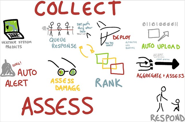
A great example of this was the Civil Air Patrol ad-hoc session. CAP is the official civilian auxiliary organization of the Air Force. It operates as a volunteer organization similar to the Boy Scouts, and also has strong ties to FEMA. They operate a network of private light planes around the US. CAP gets the first aerial imagery after a disaster, allowing the incoming responders to know where their efforts would be best focused. Currently, it’s time consuming to figure out the spot on a map that corresponds to an image and to assess damage. The planes have GPS, but the GPS is for where the camera is, and unlike custom survey aircraft, they can’t take pictures straight down and don’t record camera angle.

We talked about changing the way deployment happens – pulling from things like Geo Commons and other social media platforms to help the commander set routes for the pilots. We started scheming how to standardize the way the camera is mounted, held, or tracked to make geocoding the image easier. Our working group also laid the foundation for automating image uploading and sending those images to be crowd-sourced for damage detection. We’ll talk more about it as it moves along, but it’s a big deal that these organizations are opening up to interacting (and even requesting assistance) from digital humanitarians and volunteer technical communities. Part of why groups like GWOB are valuable to RELIEF is bringing ad-hoc and community development to experienced groups, highlighting the best of both worlds.
Tomorrow, an entry on security and cultural legibility will follow this entry as its second part.
